

In urban planning, geometry shapes how city layouts and networks develop. Historic grids create organized, easily expandable patterns that simplify property and infrastructure design. Modern corridors, like highways and rail lines, connect different parts of the city while adapting to natural features. These elements work together, balancing tradition and innovation to make cities more navigable and resilient. Exploring how geometry influences urban environments can reveal surprising insights about how cities grow and function.
Key Takeaways
- Urban layouts often utilize grid patterns for organized land division and easy navigation.
- Geometric principles guide the design of transportation corridors to optimize connectivity and flow.
- Historical grids provide a stable foundation, while modern corridors add flexibility and efficiency.
- Integration of natural features with geometric layouts enhances urban accessibility and environmental harmony.
- Balancing traditional grids with modern networks ensures resilient, navigable, and adaptable city environments.
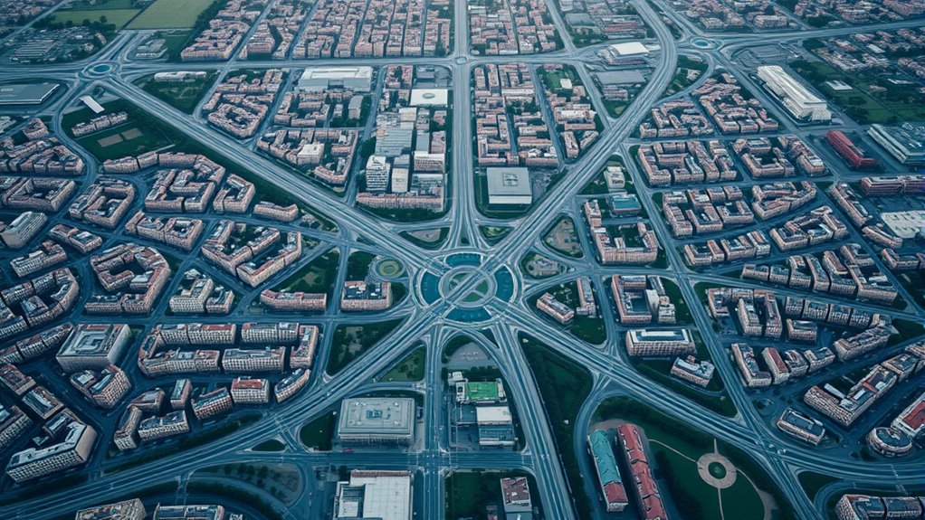
Have you ever wondered how cities seem to fit together so seamlessly? It’s all about the careful planning of city layouts, which often relies heavily on geometry. One of the most recognizable approaches is the use of historical grid patterns. These grids, often laid out centuries ago, form the backbone of many old towns and city centers. They’re simple, efficient, and easy to navigate, making it straightforward for residents and visitors alike. These patterns typically feature streets that intersect at right angles, creating a network of squares or rectangles. This geometric simplicity allows for easy expansion and modification over time, helping cities grow without losing their foundational order. The grid pattern also facilitates land division, property assignment, and infrastructure development, making it a practical choice historically. Even today, many cities retain these patterns as a nod to tradition, or because they still serve the functional needs of urban life. Grid patterns demonstrate how geometric principles can influence urban design in both historic and modern contexts.
However, as cities evolve, so do their transportation needs. That’s where modern transportation corridors come into play. These are the major routes—highways, rail lines, and arterial roads—that connect different parts of a city or link urban areas to surrounding regions. Unlike the rigid, block-like structure of historical grids, transportation corridors follow a more flexible, often curving design that adapts to geographical features and urban growth. They cut through the existing layout, facilitating faster movement and reducing congestion. These corridors are carefully integrated into the city’s overall geometry, often running along natural features like rivers or valleys, or aligning with existing grid lines for efficiency. They serve as vital arteries, supporting economic activity by enabling quick access between residential neighborhoods, commercial districts, and industrial zones. The design of these corridors influences urban development patterns, encouraging sprawl or denser growth along their routes. When planning these pathways, urban designers consider factors like traffic flow, safety, and environmental impact, all while maintaining a cohesive city layout.
The interplay between historical grid patterns and modern transportation corridors demonstrates how geometry shapes urban environments. The grid provides a stable foundation, while transportation routes introduce connectivity and flexibility. Together, they ensure cities are both navigable and adaptable, balancing tradition with progress. Whether you’re walking through a historic downtown or driving along a major highway, the underlying geometric principles make the city feel organized and accessible. This harmony between past and present in city planning highlights how essential geometry is to creating functional, resilient urban spaces that serve the needs of their inhabitants.
ALVIN, TD1150, Home Planning and Layout Template, Drawing and Drafting Tool for Artists, Architects, Design and Drafting
- Builder's Architecture Symbols: Includes various drawing symbols and gauges
- Transparent Plastic Material: Allows easy positioning over drawings
- Suitable for Students and Professionals: Ideal for architects, designers, and engineers
As an affiliate, we earn on qualifying purchases.
As an affiliate, we earn on qualifying purchases.
Frequently Asked Questions
How Does Geometry Influence Public Transportation Efficiency?
Geometry influences your public transportation efficiency by shaping routes that minimize travel distances and reduce traffic congestion. When planners use geometric principles, they optimize transit routes for directness and accessibility, making your commute faster and more reliable. This strategic layout helps avoid unnecessary detours, streamlines transit networks, and boosts overall efficiency, so you spend less time stuck in traffic and more time reaching your destination comfortably.
What Role Does Fractal Geometry Play in City Design?
Fractal geometry shapes city design by creating complex, self-similar patterns that enhance city aesthetics and functionality. You might think these patterns are just visual; however, they improve traffic flow, pedestrian movement, and infrastructure scalability. By integrating fractal patterns, you craft a city that feels natural and efficient, balancing beauty and practicality. This approach helps you design urban spaces that adapt seamlessly to growing populations and evolving needs.
How Are Historical City Layouts Different Geometrically From Modern Ones?
You’ll notice that historical city layouts often follow organic, irregular patterns influenced by historical cartography, which prioritized proximity and terrain. In contrast, modern designs emphasize geometric precision, grid systems, and efficient traffic flow. This shift enhances urban aesthetics and functionality. You see the difference in the complexity and symmetry of modern city plans versus the more natural, less structured flow of historical layouts, reflecting evolving priorities in urban development.
Can Geometric Principles Predict Urban Growth Patterns?
You can use geometric principles to predict urban growth patterns, as studies show cities expanding along specific axes or grids, which influence urban sprawl. By analyzing zoning patterns and spatial layouts, you’ll notice predictable development trends, helping to plan infrastructure and manage growth. About 75% of cities worldwide follow geometric growth models, making these principles valuable tools for forecasting and guiding sustainable urban development.
How Does Geometry Impact Pedestrian Flow and Safety?
Geometry directly impacts pedestrian flow and safety by shaping public spaces and street intersections. When you design with geometric principles, you create intuitive pathways that guide pedestrians smoothly, reducing confusion and accidents. Well-placed street intersections with clear sightlines and balanced layouts encourage safe crossing and efficient movement. Good geometric planning guarantees public spaces feel accessible and secure, helping pedestrians navigate urban environments comfortably and confidently.
HOUSTON STREET MAP & ATLAS: Detailed Road Maps with Complete Street Coverage, Neighborhood Layouts, Highway Connections, and Major Landmarks across Texas Largest city (USA Street Map Series)
As an affiliate, we earn on qualifying purchases.
As an affiliate, we earn on qualifying purchases.
Conclusion
By understanding geometry in urban planning, you can shape city layouts that flow like a well-orchestrated symphony. Every street, park, and building becomes a note in a harmonious network designed for efficiency and beauty. When you apply these geometric principles, your city transforms into a living, breathing organism—smoothly connecting people and places. Embrace these tools, and you’ll craft urban landscapes that are as functional as they are inspiring.

Advances in Human Factors in Architecture, Sustainable Urban Planning and Infrastructure (Lecture Notes in Networks and Systems)
As an affiliate, we earn on qualifying purchases.
As an affiliate, we earn on qualifying purchases.

USA GPS Map for Garmin Devices on MicroSD
- Latest June 2026 Map Update: Includes hotels, restaurants, attractions
- Turn-by-Turn Voice Directions: Provides clear navigation guidance
- Plug & Play Compatibility: Works with most Garmin devices
As an affiliate, we earn on qualifying purchases.
As an affiliate, we earn on qualifying purchases.