
Computational geometry plays a essential role in GIS mapping and spatial analysis by providing tools like Voronoi diagrams and convex hulls. These structures help you analyze proximity, define regions, and visualize spatial relationships effectively. Using these techniques, you can optimize resource distribution, understand influence zones, and simplify complex boundaries. Mastering these concepts enables you to create more accurate maps and insights—keep exploring to discover how these tools can transform your GIS projects.
Key Takeaways
- Computational geometry provides algorithms for generating spatial structures like Voronoi diagrams and convex hulls, essential for GIS mapping.
- These structures help visualize and analyze spatial relationships, influence zones, and resource distributions in geographic datasets.
- Integrating computational geometry enhances the efficiency and accuracy of large-scale spatial data processing and spatial analysis.
- Techniques like Voronoi diagrams assist in service area delineation, optimal site placement, and resource allocation strategies.
- Mastery of computational geometry principles improves GIS applications by enabling advanced spatial modeling and visualization capabilities.
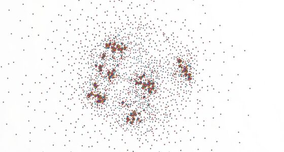
GIS mapping and spatial analysis have revolutionized how we comprehend and interpret geographic data. They enable you to visualize complex spatial relationships, uncover patterns, and make informed decisions. One of the key tools in this domain is computational geometry, which provides algorithms and structures to analyze spatial data efficiently. For example, Voronoi diagrams are fundamental in dividing space based on proximity. When you generate a Voronoi diagram, you’re creating a map that partitions an area into regions around each point, ensuring that every location within a region is closest to its associated point. This method proves invaluable for applications like cell tower placement, emergency services, and resource allocation, where understanding the influence zones around specific sites is critical.
Alongside Voronoi diagrams, convex hulls play an essential role in spatial analysis. Think of a convex hull as the smallest convex shape that encloses a set of points. When you compute the convex hull of a group of locations, you’re effectively drawing a boundary that contains all the points with the least perimeter. This technique helps in understanding the overall extent of a dataset, simplifying complex shapes into manageable polygons, and identifying outliers or clusters. For instance, if you’re analyzing animal migration patterns, convex hulls can help you determine the core area used by a species and distinguish it from sporadic or distant sightings.
Both Voronoi diagrams and convex hulls serve as building blocks for more advanced spatial analyses. You might combine them to delineate service areas, optimize location planning, or analyze spatial density. When working with large datasets, these structures allow you to perform operations quickly and accurately, saving time and computational resources. For example, generating a Voronoi diagram around multiple facilities helps you visualize service coverage, while the convex hull can define the boundary of a region of interest, such as a city or a protected habitat. Additionally, understanding the fundamental principles of computational geometry enhances your ability to develop innovative solutions in GIS applications.

GEOGRAPHIC INFORMATION SYSTEM FOR BEGINNERS: A Practical Guide to GIS Fundamentals, Applications, Mapping, and Spatial Analysis (Julian's Technology, Innovation and Information Guides)
As an affiliate, we earn on qualifying purchases.
As an affiliate, we earn on qualifying purchases.
Frequently Asked Questions
How Does Computational Geometry Improve Real-Time GIS Data Processing?
Computational geometry enhances real-time GIS data processing by optimizing algorithm efficiency and data structures. You can quickly analyze complex spatial data, such as point-in-polygon tests or shortest path calculations, because these algorithms are designed for speed. Efficient data structures like R-trees or quad-trees diminish search times, enabling you to process large datasets swiftly. This ensures timely, accurate mapping and spatial analysis, even with rapidly changing or massive data streams.
What Are the Limitations of Current Algorithms in Large-Scale Spatial Analysis?
Imagine trying to untangle a massive web of interconnected threads; that’s what large-scale spatial analysis feels like. Your current algorithms face scalability issues, struggling to process vast datasets efficiently. Algorithm complexity grows exponentially with data size, causing delays and potential inaccuracies. These limitations hinder real-time insights, making it difficult to handle the ever-expanding volume of spatial data, and highlighting the need for more scalable, optimized computational geometry solutions.
How Can GIS Integrate With Emerging Technologies Like AI and Machine Learning?
You can integrate GIS with emerging technologies like AI and machine learning by focusing on data integration, enabling seamless combination of spatial and non-spatial data. Machine learning algorithms can analyze complex patterns and predict trends, enhancing decision-making. To do this effectively, you should develop workflows that incorporate real-time data streams and guarantee compatibility between GIS platforms and AI tools, opening new insights and automating spatial analysis processes.
What Are the Challenges in Modeling Complex Terrains Using Computational Geometry?
Modeling complex terrains can feel like trying to tame a wild beast. You face challenges in terrain modeling, where data complexity and irregular shapes demand advanced algorithms. Simplifying data without losing essential details is tricky, often leading to oversimplification or inaccuracies. Handling diverse topographies, ensuring precision, and managing large datasets stretch computational geometry techniques to their limits. These hurdles make accurate, detailed terrain modeling a tough but rewarding pursuit.
How Does Computational Geometry Handle Data Inaccuracies or Uncertainties in GIS?
You handle data inaccuracies in GIS by employing error handling techniques and uncertainty modeling. Computational geometry tools identify and mitigate errors through algorithms that detect inconsistencies, while uncertainty modeling quantifies the confidence levels in your data. This approach allows you to make informed decisions despite imperfections, ensuring your spatial analysis remains robust. By integrating these methods, you effectively manage inaccuracies and improve the reliability of your GIS insights.

Finite Elements-based Optimization: Electromagnetic Product Design and Nondestructive Evaluation
As an affiliate, we earn on qualifying purchases.
As an affiliate, we earn on qualifying purchases.
Conclusion
As you explore deeper into computational geometry in GIS, you realize the potential to open hidden patterns and insights. Every map you create and analysis you perform brings you closer to uncovering secrets buried within data. But beware—there’s always more to discover, more layers to reveal. Are you ready to push the boundaries further? The next breakthrough might be just around the corner, waiting for you to access it.

GROCO Thru-Hull Installation Tool
Great Product
As an affiliate, we earn on qualifying purchases.
As an affiliate, we earn on qualifying purchases.

The Esri Guide to GIS Analysis, Volume 2: Spatial Measurements and Statistics
As an affiliate, we earn on qualifying purchases.
As an affiliate, we earn on qualifying purchases.