

To start with coordinate geometry, you’ll need to learn how to plot points using their x and y coordinates. Move along the x-axis first, then vertically along the y-axis to locate the exact spot on the grid. Practice plotting various points and drawing lines between them to see their geometric relationships clearly. With basic skills in plotting and understanding coordinates, you’ll build a strong foundation. Keep exploring, and you’ll discover even more helpful tips for mastering the concepts.
Key Takeaways
- Learn to read coordinates accurately to plot points precisely on the graph.
- Move along the x-axis first, then the y-axis, to locate points correctly.
- Use the distance formula derived from the Pythagorean theorem to find lengths between points.
- Practice plotting points and drawing lines to visualize geometric relationships clearly.
- Develop confidence through regular practice in plotting and calculating distances in coordinate geometry.
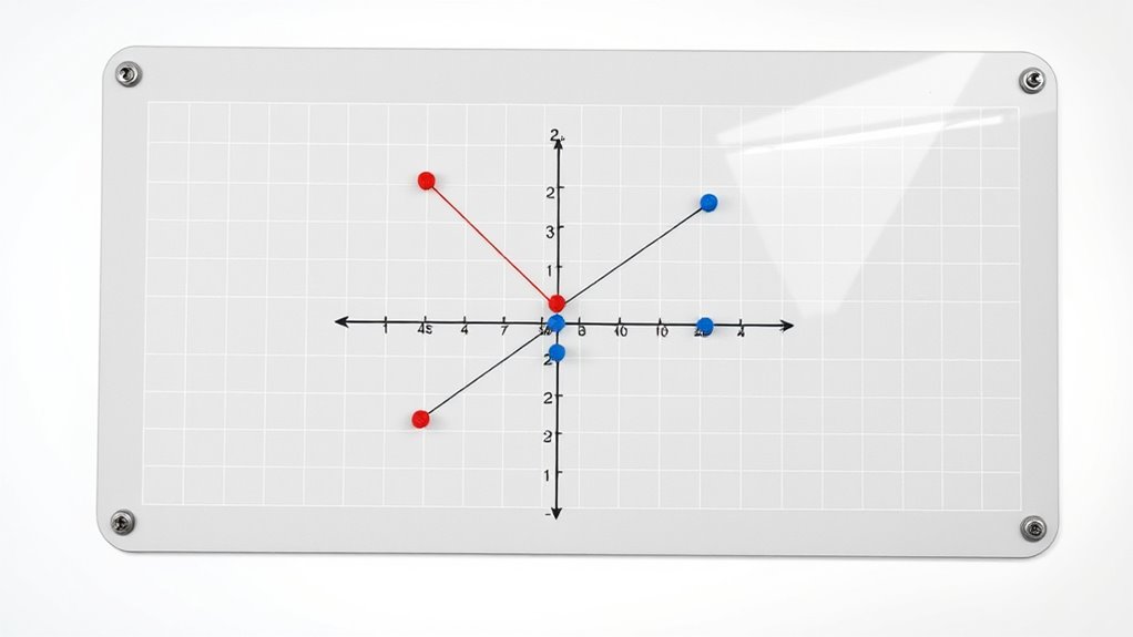
Have you ever wondered how to find the exact location of a point or the distance between two points on a graph? If so, you’re about to discover some simple yet powerful methods to traverse coordinate geometry with confidence. When you start plotting points, understanding basic graphing techniques is essential. These techniques involve reading and interpreting the x and y coordinates accurately, which tell you precisely where to place each point on the grid. For example, if you have a point (3, 4), you move 3 units along the x-axis and 4 units up the y-axis from the origin. This straightforward approach helps you visualize the points clearly and guarantees your graph is accurate.
Once you’re comfortable plotting individual points, the next step is understanding how to determine the distance between two points. This is where distance formulas come into play. The distance formula is derived from the Pythagorean theorem and allows you to calculate the straight-line distance between any two points on a coordinate plane. If you have points (x₁, y₁) and (x₂, y₂), the distance (d) between them is given by the formula:
[ d = sqrt{(x₂ – x₁)^2 + (y₂ – y₁)^2} ]Master the distance formula to find the exact length between any two points on a coordinate plane.
This formula might look intimidating at first, but once you break it down, it’s simply a matter of subtracting the x and y coordinates, squaring those differences, adding them, and then taking the square root. It’s a quick way to find the shortest distance, which is especially useful when working with real-world problems, like measuring the distance between two cities on a map or the length of a diagonal across a rectangle. Understanding coordinate plane concepts can help you visualize the geometric relationships more clearly and improve your problem-solving skills.
Practicing these techniques helps you become more confident in handling coordinate geometry problems. Start by plotting a few points, then use the distance formula to find the distance between each pair. With consistent practice, you’ll develop an intuitive sense for how points relate to each other on the plane. Remember, mastering these fundamental skills makes plotting lines and solving more complex problems much easier. As you become more familiar with graphing techniques and distance formulas, you’ll find that coordinate geometry is less about memorizing formulas and more about visualizing relationships and understanding the geometry behind the numbers. So, keep practicing by plotting points, calculating distances, and exploring different configurations. Before long, traversing the coordinate plane will feel natural and straightforward.

Circular Grid Sketchbook: Polar Coordinates (8.5×11) Graph Paper Notebook With 100 Pages and 99 Graphs
As an affiliate, we earn on qualifying purchases.
As an affiliate, we earn on qualifying purchases.
Frequently Asked Questions
How Do I Find the Distance Between Two Points?
To find the distance between two points, you use the distance formula derived from the Pythagorean theorem. First, find the difference in their x-coordinates and y-coordinates, then square these differences. Add the squared values, and take the square root of the sum. This process relates to vector addition and coordinate transformations, helping you understand how points relate in space. It’s a fundamental skill for plotting and analyzing points accurately.
What Is the Midpoint Formula Used For?
You use the midpoint formula for midpoint calculation, which helps you find the exact point halfway between two coordinates. This is especially useful in coordinate bisectors, where you need to identify the center point of a segment. By applying this formula, you can accurately locate the middle point, simplifying tasks like constructing perpendicular bisectors or understanding the balance point of a line segment in coordinate geometry.
How Can I Determine if Points Are Collinear?
Your brain’s about to explode with this insight! To determine if points are collinear, do a quick collinearity check: compare the slopes between each pair of points. If all slopes are equal, then the points lie on the same straight line. This slope comparison method is a simple yet powerful way to verify collinearity without complex calculations, ensuring your geometric intuition stays sharp and precise.
What Are the Applications of Coordinate Geometry in Real Life?
You can see coordinate geometry’s real-life uses in many areas. It helps you map city layouts accurately, making navigation and urban planning easier. You also use it to design game graphics, creating precise and visually appealing images. By understanding how points and lines interact, you can develop better maps and graphics, improving technology and daily life. Its applications make complex tasks manageable and more efficient in various fields.
How Do I Convert Between Different Coordinate Systems?
Did you know that GPS systems rely on coordinate transformations to pinpoint locations? To convert between coordinate systems, like from polar to Cartesian plane, you perform a coordinate transformation. You’ll need to apply formulas that change the data’s reference frame, such as converting angles and distances into x and y coordinates. This process helps in mapping, navigation, and various engineering tasks, making it essential for understanding how different coordinate systems work together seamlessly.
Mead Spiral Notebook, 1 Subject, Graph Ruled Paper, 7-1/2" x 10-1/2", 100 Sheets, Green (05676AC5)
1 subject notebook comes with 100 graph ruled, double-sided sheets with 5 squares per inch
As an affiliate, we earn on qualifying purchases.
As an affiliate, we earn on qualifying purchases.
Conclusion
Now that you’ve learned how to plot points and lines, you’re well on your way to mastering coordinate geometry. Did you know that over 80% of top engineers use coordinate plotting daily? With this skill, you’ll confidently tackle more complex problems and visualizations. Keep practicing, and soon you’ll find it second nature. Remember, the key is to stay curious and keep experimenting—you’re building a powerful tool for understanding the world around you!

Westcott B-70 8ths Graph Beveled Ruler, 12 in
Elevate Your Drafting Experience – Our Westcott ruler is the perfect addition to your school supplies. The 12…
As an affiliate, we earn on qualifying purchases.
As an affiliate, we earn on qualifying purchases.

Sharp Calculators EL-243SB 8-Digit Pocket Calculator
Hinged, hard cover protects keys and display when stored
As an affiliate, we earn on qualifying purchases.
As an affiliate, we earn on qualifying purchases.