

In construction, local grid coordinate systems provide a familiar, consistent frame that simplifies onsite measurements and aligns with site layouts, but they may lack global compatibility. GPS coordinates offer quick, precise location data over large areas and facilitate real-time positioning, yet environmental factors can affect accuracy. Choosing the right system depends on your project scope and environment; understanding how both work can help you optimize site planning—more insights await if you continue exploring.
Key Takeaways
- Local grid coordinate systems provide precise, site-specific reference points, reducing reliance on external signals and improving onsite measurement consistency.
- GPS coordinates enable rapid, large-area positioning but can be affected by environmental factors, impacting accuracy and reliability.
- Local grids are cost-effective for detailed tasks but require regular calibration and maintenance for sustained accuracy.
- GPS coordinates facilitate quick site mapping and coordination over extensive areas, ideal for large-scale projects.
- Combining local grid systems with GPS data enhances overall project precision, efficiency, and data integration in construction workflows.
What Are Local Grid Coordinate Systems and How Do They Work?

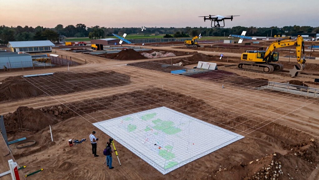
Local grid coordinate systems are specialized frameworks used in construction to precisely locate and navigate points on a site. They help improve survey accuracy by establishing a consistent reference point, making it easier to interpret measurements. These systems work by defining a grid with specific axes and origins tailored to the project’s needs. When working across different coordinate systems, coordinate transformation is essential to convert data accurately, ensuring all points align correctly. Application of coordinate transformation is crucial for maintaining spatial accuracy across diverse systems. This process minimizes errors and maintains spatial consistency throughout the project. Additionally, understanding the relationship between local and global coordinate systems can help in integrating site data with larger-scale mapping efforts. By using local grid systems, you can efficiently manage site layout, reduce mistakes, and streamline construction workflows. Overall, these systems are crucial tools for achieving precise, reliable measurements in complex construction environments.
How GPS Coordinates Are Used in Construction Projects

How do GPS coordinates enhance accuracy in construction projects? They improve mapping accuracy by providing precise location data, which helps guarantee structures are built exactly where planned. Using GPS, you can quickly gather accurate site measurements without relying solely on traditional surveying methods. This data integration allows you to overlay GPS coordinates with existing maps and design plans seamlessly, reducing errors. GPS technology supports real-time positioning, enabling better coordination among teams and contractors. It also accelerates project timelines by decreasing manual measurement efforts. Additionally, leveraging European cloud servers can facilitate secure and efficient data management for large construction datasets. Employing modern satellite technology ensures even greater precision and reliability in positioning. The use of automated data collection tools further streamlines workflows and minimizes human error. The integration of advanced data systems further enhances overall project management and decision-making. Ultimately, GPS coordinates enable you to achieve high precision throughout the construction process, minimizing costly mistakes and rework. Their role in enhancing mapping accuracy makes GPS an invaluable tool for modern construction projects.
Which Is More Accurate: Local Grid or GPS?

GPS technology has revolutionized accuracy in construction, but traditional local grid systems still play a pivotal role. When comparing survey accuracy, local grids often excel in stability over time, unaffected by satellite signal issues. They maintain consistent positioning even in challenging environments. GPS can be highly accurate but faces technological limitations like signal interference and atmospheric conditions. To visualize this, consider the table below:
| Aspect | Local Grid | GPS |
|---|---|---|
| Survey Accuracy | Consistent, reliable | Varies with conditions |
| Technological Limits | Minimal | Signal interference, errors |
| Long-term Stability | High | Can fluctuate |
While GPS offers flexibility, local grids provide steady, dependable survey accuracy, especially where technology faces limitations. Additionally, local grid systems are often more cost-effective for large-scale projects due to reduced dependency on satellite signals. Furthermore, ongoing advancements in surveying techniques continue to influence the choice between these systems, emphasizing the importance of understanding their respective accuracy factors. Understanding the factors involved can help in selecting the most suitable system for specific project requirements.
Pros and Cons of Local Grid Coordinate Systems
Local grid coordinate systems are easy to use on-site, making daily work more efficient. However, they often lack global compatibility, which can complicate sharing data across projects. Additionally, maintaining and updating these systems requires ongoing effort to guarantee accuracy.
Ease of Local Use
Are local grid coordinate systems truly easy to use on construction sites? For many, they simplify tasks because you can rely on familiar references rather than complex digital mapping. Here are some advantages:
- They reduce the need for constant coordinate transformation, making onsite measurements straightforward.
- Local grids often align with existing site layouts, helping you avoid confusion during construction.
- Using a local grid minimizes dependency on external signals, ensuring consistent measurements even in remote areas.
- Familiarity with the Free Floating concept can help users better understand how local systems operate within broader geographic contexts.
- Additionally, understanding how project management support integrates with local coordinate systems can enhance overall workflow efficiency.
Limited Global Compatibility
While local grid coordinate systems offer ease of use on construction sites, their limited compatibility with global standards can create challenges. You might find that these systems have global inconsistency, making it difficult to coordinate projects across different regions or with international teams. Regional limitations mean that local grids often don’t align with GPS or other worldwide coordinate systems, leading to potential errors when sharing data or shifting between different mapping methods. This can cause delays, increased costs, or inaccuracies in large‑scale projects that require seamless integration. Additionally, relying solely on local grids restricts your ability to leverage global positioning technologies, which are becoming standard in modern construction. Recognizing these limitations helps you make informed decisions about when to adopt or supplement local coordinate systems with global solutions. Understanding heat distribution in mapping and positioning systems can improve accuracy and integration across different coordinate frameworks. Incorporating coordinate system compatibility considerations from the outset can streamline project workflows and reduce costly adjustments later. Moreover, being aware of global standards can facilitate better collaboration and data sharing across teams worldwide. A comprehensive understanding of local and global coordinate systems is essential for effective project management and precision in construction.
Maintenance and Updates
Have you considered how maintaining and updating local grid coordinate systems impacts your construction projects? Regular maintenance involves coordinate calibration to guarantee accuracy, which can be time-consuming but essential for precision. coordinate calibration is indispensable for maintaining accuracy but demands ongoing effort. Updating the system often requires re-calibration and seamless system integration to prevent discrepancies. Proper system integration ensures updates are smooth, preventing misalignments and errors. Additionally, ongoing maintenance is necessary to adapt to evolving project needs and technological advances. Proper system integration ensures updates are smooth, preventing misalignments and errors. Proper documentation of calibration procedures is critical for consistent maintenance and future updates.
While local grids can be cost-effective initially, their maintenance and update requirements can be resource-intensive, especially compared to more flexible systems like GPS. Proper upkeep guarantees ongoing accuracy, critical for construction success.
Advantages and Drawbacks of Using GPS Coordinates
GPS coordinates offer significant advantages in construction, such as quick and accurate site positioning, which streamlines planning and reduces errors. They enhance survey accuracy by providing precise location data over large areas, making site layout more efficient. However, signal reliability remains a concern; GPS signals can be disrupted by dense foliage, tall structures, or weather conditions, leading to potential inaccuracies. This dependency on signals means that in some environments, GPS may not always deliver consistent results. While GPS coordinates speed up initial site setup and improve overall accuracy, you must also consider potential signal interruptions that impact reliability. Additionally, technological limitations can impact the effectiveness of GPS in certain scenarios, emphasizing the importance of backup systems. Being aware of signal obstruction and having alternative navigation options in place can further enhance construction efficiency and safety, especially in challenging environments. Understanding environmental factors that affect signal strength, such as atmospheric conditions, is crucial for maintaining reliable positioning. Furthermore, ongoing advancements in nanotechnology could lead to the development of more resilient and precise navigation devices in the future. Balancing these factors helps determine when GPS is advantageous and when alternative systems might be necessary for critical tasks.
When Should You Use Local Grid or GPS Coordinates?

You’ll want to contemplate project scale and the needed level of precision when choosing between local grid and GPS coordinates. Larger sites or projects requiring high accuracy often benefit from local grids, while GPS is ideal for quick, broad positioning. Also, think about site accessibility and location—remote or hard-to-reach areas may influence your choice.
Project Scale and Precision
Choosing the right coordinate system depends largely on the project‘s scale and required precision. For small, detailed tasks like survey accuracy and data integration, local grids often provide higher precision and control. Conversely, GPS coordinates are ideal for large-scale projects where broad location data suffices. Consider these points:
- Use local grids when precision is critical, such as for detailed surveying and small construction elements.
- Opt for GPS coordinates for large sites to streamline data collection and improve efficiency.
- Match your coordinate system to the project’s scope—local grids offer better survey accuracy, while GPS simplifies coordination over extensive areas.
Site Accessibility and Location
When evaluating site accessibility and location, selecting the appropriate coordinate system depends on how easily you can reach and navigate the area. If the site is remote or difficult to access, GPS coordinates offer quick, precise positioning, improving construction safety by reducing navigation errors. They simplify material logistics, enabling delivery trucks and equipment to locate the site efficiently. Conversely, if the site is within a well-mapped area with established local grids, using a local grid system provides familiarity and stability, especially for ongoing operations. Local grids are less affected by GPS signal disruptions, ensuring consistent reference points. Ultimately, consider the site’s accessibility, safety requirements, and logistical needs when choosing between local grid and GPS coordinates to optimize construction workflows.
How to Combine Local Grid and GPS Systems for Better Planning

To enhance construction planning accuracy, it’s essential to effectively combine local grid systems with GPS technology. This coordinate system integration boosts planning optimization by leveraging the strengths of both methods. Here’s how you can do it:
- Establish a common reference point between your local grid and GPS data to align both systems precisely.
- Use GPS for large-scale positioning and navigation, then refine with local grid measurements for detail accuracy.
- Regularly update and verify data to maintain the integration’s integrity throughout the project.
Frequently Asked Questions
How Do Coordinate Systems Impact Construction Project Timelines?
Coordinate systems directly impact your construction project timelines by ensuring precise location data, which streamlines project scheduling and resource allocation. When you use accurate coordinates, you can avoid delays caused by misaligned measurements or rework. This efficiency allows your team to stay on schedule, reduces errors, and optimizes resource use, ultimately leading to quicker project completion and better coordination among stakeholders.
Can Local Grid Systems Be Integrated With GPS Data Seamlessly?
Think of integrating local grid systems with GPS data as stitching together a well-woven tapestry. You can seamlessly connect them through digital mapping and coordinate conversion, making certain both systems align accurately. This process ensures precise positioning for your project, reducing errors and delays. With proper tools and methods, merging local grids with GPS data becomes smooth sailing, helping you stay on schedule and within budget.
What Training Is Needed for Workers to Use GPS Coordinates Effectively?
To use GPS coordinates effectively, you need proper training in GPS calibration and digital mapping. You should learn how to calibrate GPS devices for accuracy, interpret digital maps, and understand coordinate systems. Hands-on practice helps you become familiar with data collection and error correction. Additionally, training should cover troubleshooting common GPS issues and integrating GPS data with project plans, ensuring precise positioning and efficient construction workflows.
Are There Legal Standards Governing Coordinate System Use in Construction?
Think of legal standards in construction like a sturdy backbone guiding your project. Yes, there are regulations governing coordinate system use, emphasizing legal compliance and standardization. These rules guarantee consistency across projects, preventing costly mistakes. Staying updated with local and national standards keeps your work aligned with legal requirements, much like a compass guiding a sailor. Ignoring these standards risks penalties and delays, so always follow the prescribed coordinate system regulations diligently.
How Do Environmental Factors Affect GPS Accuracy On-Site?
Environmental factors like signal interference and atmospheric conditions can considerably impact GPS accuracy on-site. You might experience degraded signals due to dense foliage, tall buildings, or electronic interference, which cause errors in positioning. Atmospheric conditions, such as ionospheric and tropospheric delays, can also distort signals, making your GPS readings less reliable. To maintain precision, you should account for these factors, use ground-based correction methods, and choose best times for surveying.
Conclusion
Choosing between local grid and GPS coordinates is like selecting the right tool for a job—you’ll want the one that fits your project’s terrain and precision needs. Think of local grids as your reliable compass, steady and familiar, while GPS is the high-tech navigator, offering flexibility and real-time updates. By blending both systems, you create a seamless map that guides your construction journey smoothly from blueprint to reality, turning complex terrain into a well-charted adventure.